2026-07-27 23:32:21
Latest Post
 Welspun Corp Ltd receives new order worth Rs. 960 crores
 Sigma Advanced Systems Secures USD 104.9 Million Export Order for Next-generation Extended Range 155mm Base Bleed Artillery Shells
 Linc Unveils its Retail Outlet-cum-Product Experience Centre under the Brand 'Stackoo' in Kolkata
 VIDA Marks its Global Debut with Entry into Nepal
 Zen Technologies Unveils India's First High-Altitude Man-Portable Anti-Drone System for Modern Mountain Warfare
General
Deep depression over southwest Bay of Bengal to cross South Tamil Nadu coast
Posted On : 2009-12-13 18:48:21( TIMEZONE : IST )

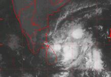 The deep depression over southwest Bay of Bengal moved westwards and lay centred at 2330 hours IST of yesterday, 13th December 2009 near lat. 9.00 N and long. 82.50 E, about 130 km east-northeast of Trincomalee (Sri Lanka), 330 km southeast of Nagapattinam and 350 km east of Pamban. The system is likely to move in a westerly direction and cross north Sri Lanka near Lat. 9.00 N around noon of today, the 14th December, 2009. Subsequently, it is likely to move in a west-southwesterly direction, emerge into Gulf of Mannar and cross south Tamil Nadu coast between Kanyakumari and Pamban around afternoon of tomorrow, the 15th December, 2009.
Under its influence, rainfall at many places with isolated heavy to very heavy falls is likely over north coastal Tamilnadu and Puducherry during next 48 hours. Rainfall at many places with isolated heavy to very heavy falls is also likely over south coastal Tamil Nadu during next 24 hours. Rainfall at most places with scattered heavy to very heavy falls and isolated extremely heavy falls (≥ 25 cm) is also likely over south coastal Tamil Nadu for the subsequent 48 hours.
Squally winds speed reaching 55-65 kmph gusting to 75 Kmph are likely along and off south Tamil Nadu coast during next 48 hours . Squally winds speed reaching 50-60 kmph gusting to 70 kmph is also likely along and off north Tamil Nadu and Puducherry coast during next 24 hours. Sea condition will be very rough to high along and off south Tamil Nadu coast and very rough along and off north Tamil Nadu and Puducherry coasts.
Damage expected: Minor damage to loose and unsecured structures
Action suggested: Fishermen are advised not to venture into the open sea.