2026-07-17 04:15:41
Latest Post
 Diamond Power Infrastructure Ltd secures conductor supply order of Rs. 185 Crore from Adani Energy Solutions Ltd
 GRE Renew Enertech Ltd receives orders worth Rs. 23.99 crores
 Atishay Limited awarded order worth Rs. 49.35 lakhs
 Ajmera Realty Q1 FY27 Operations: Sales Value Surges 35% to ₹146 Crore Powered by Strong Portfolio Realizations
 CEAT Ltd - Q1 FY26-27 Consolidated Revenue Rs. 4,318 crore, up 22 % Y-o-Y
General
Deep Depression over Bay of Bengal to intensify as Cyclonic Storm
Posted On : 2009-12-11 04:17:08( TIMEZONE : IST )

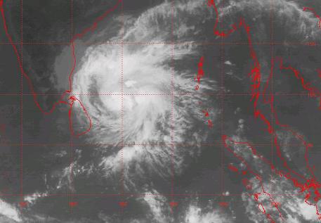 The deep depression over southwest and adjoining southeast Bay of Bengal moved northwards and lay centred at 1130 hours IST of today, the 11th December 2009 near lat. 8.00 N and long. 84.50 E, about 300 km east of Batticaloa (Sri Lanka), 580 km southeast of Nagapattinam and 700 km southeast of Chennai. The system is likely to intensify further into a cyclonic storm and move in a northwesterly direction towards Tamil Nadu coast skirting, Sri Lanka coast during next 48 hours.
However, satellite derived steering wind in upper troposphere suggests northerly / northeasterly movement of the system. Considering all the above the system is under watch.
Under its influence, rainfall at many places with isolated heavy to very heavy falls is likely to commence over coastal Tamilnadu and Puducherry from tomorrow, the 12th December 2009 morning. Subsequently, increase in rainfall activities with scattered heavy to very heavy falls and isolated extremely heavy falls is likely over south coastal Tamilnadu from 12th December 2009 evening onwards.
Squally winds speed reaching 55-65 kmph gusting to 75 kmph are likely to commence along and off Tamilnadu and Puducherry coasts from tomorrow, the 12th December 2009 morning. Sea condition will be very rough to high along and off these coasts. Fishermen are advised not to venture into the sea along and off these coasts.